Sri Lanka’s repeated railway disruptions following extreme weather events have renewed scrutiny of a long-standing structural issue: the continued reliance on a railway corridor designed in the 19th century for a colonial economy, rather than a modern, climate-resilient transport system.
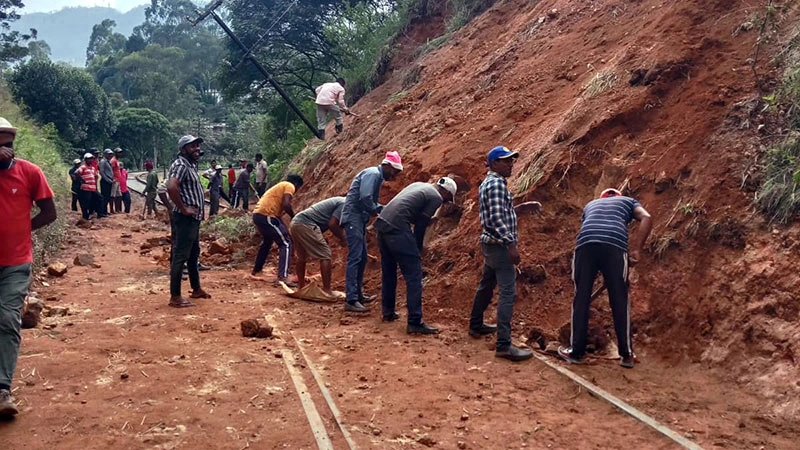
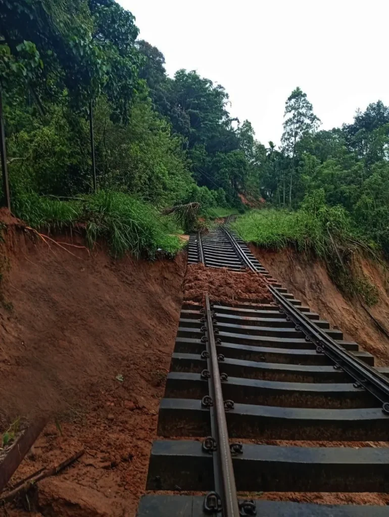
Cyclone Ditwah did not introduce a new failure into the system. Instead, it highlighted vulnerabilities that have existed for decades along the Colombo–Kandy main line, particularly between Rambukkana and Kadugannawa one of the most geologically unstable rail sections in the country.
Also in Explained | Sri Lanka Cannot Grow by Looking Inwards: Why an Export-Driven, Green Investment Brand Is No Longer Optional
A Railway Built for Extraction, Not Resilience
The Colombo–Kandy railway line was constructed in the 1860s under British colonial administration, primarily to transport coffee and later tea from the central highlands to the Port of Colombo. Its alignment was determined by plantation access and export efficiency, not by long-term national mobility, redundancy, or climate resilience.
Engineering decisions made at the time reflect this purpose. The line traverses steep gradients, tight curves, and deep cuttings through mountainous terrain. Stations were placed to serve plantations and administrative centres rather than population-based transport demand. These design features were acceptable under colonial operating assumptions, but they pose increasing challenges under modern conditions.
A Corridor with Chronic Instability
The Rambukkana–Kadugannawa section, in particular, has a long history of slope instability. Landslides and embankment failures recur in largely predictable locations, especially during periods of heavy rainfall.
Much of this instability is rooted in historical land-use changes. Large-scale deforestation for coffee and tea cultivation in the 19th century removed natural slope stabilisation, leaving soil structures vulnerable to erosion and saturation. Contemporary climate patterns characterised by more intense and concentrated rainfall have further increased failure risk.
Despite this, post-incident responses have remained largely reactive. Repairs are undertaken to restore service, but without fundamental changes to alignment, slope treatment, or corridor redundancy. As a result, the same sections remain vulnerable year after year.
FACT BOX: COLOMBO–KANDY MAIN LINE
Year construction began: 1864
Opened to Kandy: 1867
Original purpose:
- Transport coffee and tea from the central highlands to Colombo Port
- Serve plantation logistics and colonial administration
Key engineering characteristics:
- Steep gradients between Rambukkana and Kadugannawa
- Tight curvature and deep cuttings through hill country terrain
- Alignment follows plantation-era access routes rather than population centres
Current structural challenges:
- Recurrent landslides and embankment failures
- High rainfall sensitivity due to deforested slopes
- Limited redundancy; disruptions affect national passenger and freight movement
Climate risk factors:
- Increased intensity of monsoon rainfall
- Saturation-triggered slope failures in known high-risk zones
Heritage Versus Network Function
Over time, the Colombo–Kandy line has acquired symbolic and heritage value. While this status is culturally significant, it has also contributed to the line being treated as an irreplaceable national transport spine, rather than one component of a broader network.
This has practical consequences. When disruptions occur on this corridor, national passenger movement and freight logistics are affected disproportionately because alternative routes are limited or non-existent. The lack of redundancy increases economic exposure during extreme weather events.
Reconsidering Corridor Strategy
Transport planners and policy analysts have periodically raised the possibility of alternative alignments that avoid the most unstable hill country terrain. One option frequently cited is a Colombo → Kurunegala → Galagedara corridor.
From a structural perspective, this route offers several advantages. The terrain is generally more stable, and Kurunegala already functions as a major logistics and transport hub linking multiple regions. A modern corridor through this axis could support freight movement, container transport, and passenger services while reducing dependence on landslide-prone slopes.
Such an approach would also enable the Colombo–Kandy line to be repositioned. Rather than serving as the primary national artery, it could focus on commuter traffic, regional connectivity, and tourism roles more consistent with its physical constraints.
A Policy Decision Deferred
Developing a new national transport corridor would require substantial investment, long-term planning, and political commitment. These requirements have contributed to repeated deferrals, with short-term repairs favoured over structural redesign.
However, the increasing frequency of climate-related disruptions is narrowing the margin for inaction. Each major weather event reinforces the same conclusion: the current reliance on a single, historically constrained alignment carries growing economic and operational risk.
Sri Lanka’s railway system is not under strain because of a single storm. It is under strain because a network built for a colonial export economy continues to be tasked with meeting 21st-century national demands.
Cyclone Ditwah did not create this reality. It made it visible.
The policy question now is whether future investment will continue to reinforce a historically inherited corridor, or whether Sri Lanka will begin designing transport infrastructure aligned with present-day climate conditions, economic geography, and long-term national resilience.
Also in Explained | Central Bank of Sri Lanka Issues Relief Measures for Cyclone and Flood-Affected Borrowers